Thursday

Tuesday, July 17, 2007

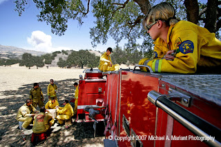
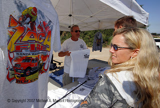
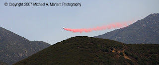
Continuing coverage of the Zaca Fire in the mountains north of Santa Barbara, Calif.: Access to the fire line is pretty much impossible as it is burning in extremely rugged terrain in a road-less wilderness area. The Calif. Dept. of Forestry is using tankers and helicopters for the primary attack and digging containment lines around the wilderness perimeter with bulldozers. Closest access via an unimproved dirt road was still three miles, yielding views of distant retardant drops from air tankers. Several staging camps are scattered in the area with firefighters taking a break from their two-week long battle with the fire, while released fire crews stop by a road-side vendor selling "Zaca Fire" t-shirts.


Monday, July 16, 2007

The Zaca Fire, burning in the mountains north of Santa Barbara, Calif. since the Fourth of July, took a wind-driven turn to the south toward a large cluster of ranch homes in rural Santa Ynez Valley, prompting evacuations. In the nearby town of Santa Ynez, a Red Cross evacuation center was set up at the local high school, where I captured workers setting up the shelter while evacuees signed in at the receiving desk.


Friday, July 13, 2007

The Point Buchon trail, south of Montana de Oro State Park in Los Osos, Calif., opened to the public for the first time Friday, July 13. The trail is on private-property, owned by Pacific Gas & Electric, providing a security buffer around Diablo Canyon Nuclear Power Plant. According to Sharon Gavin, PG&E spokesperson, the 1.8-mile bluff-top route with cliff-views, a large ocean-fed sinkhole along with access to the previously-closed Coon Creek Beach and sea caves, was established in an agreement with the California Coastal Commission for approval of the power plant's planned above-ground storage of spent radioactive fuel. Gavin says that there are plans to add two-miles to the trail network in 2008.